January 14, 2006
Re-Discovering Antarctica
The discovery and mapping of Antarctica was a long and difficult process. The weather down there isn't exactly balmy.
Here is a brief chronology of what we knew about the southern continent and when we knew it. (I snagged most of the Antarctica info from here.)
**ahem**
First, the Earth cooled. As the atmosphere scattered the Sun's rays at the poles, some of the Earth became very very cold, indeed, and life was hard pressed to flourish there as it did in the tropics and beyond. Coming out of equatorial Africa, human tribes spread throughout the continents. Into the Caucasus region; west and north into Europe; east into India, Asia and Australia they went.
From there they sailed to islands in the south Pacific and up and across a land bridge into Alaska. Tribes then traveled south into warmer lands, settling throughout North and South America and, finally, reaching the end of the world -- the island of Tierra del Fuego at the southern tip of South America -- around 12,000 years ago. Then people thought that it might be a good idea to keep track of things and they started to write stuff down.
It is now widely believed that Leif Erikson and the Vikings were the first to discover the Americas since the "Age of Recorded History" began. But, while the Vikings' explorations yielded descriptions of the new lands, they were not, let's just say, in the loop when it came to passing on that information to their contemporary scholars, which is to say, the Medieval Church.
Christopher Columbus, on the other hand, was a "legitimate" explorer with backing from the Spanish monarchy. In the autumn of 1492 he set sail west in search of a passage to Asia that didn't require sailing all the way around the southern cape of Africa. I mean, it was frickin' c-c-cold down there. Columbus never made it to Asia, of course, as he kinda ran into a wall that's now called North and South America.
In September of 1519 Ferdinand Magellan -- bent on finding a way to those Asian spices without having to brave the Cape of Good Hope -- travels south into even colder waters and navigated through the Straits of Magellan, that narrow passage between the main continent and the large island of Tierra del Fuego. Magellan surmises that Tierra del Fuego may be the northern tip of a large southern continent.
But, in 1758, Francis Drake - after having passed through the Straits of Magellan - is blown southward by a storm on the Pacific side. He discovers that Tierra del Fuego is not part of a larger continent, but merely an island. The open sea below the island's Cape Horn is now called "Drake's Passage".
In August of 1592 the Falkland Islands are discovered by John Davis. It wasn't until April of 1675 that Antonio de la Roché is blown off course and discovers the island of South Georgia, some 700 miles to the east of the Falklands. A century later, in January of 1775, Captain James Cook sails about 450-500 miles eastward past South Georgia and discovers the South Sandwich Islands. It was two years earlier, in January of 1773, that Captain Cook was the first to sail below the Antarctic Circle - about 67 S latitude - but he spied no land.
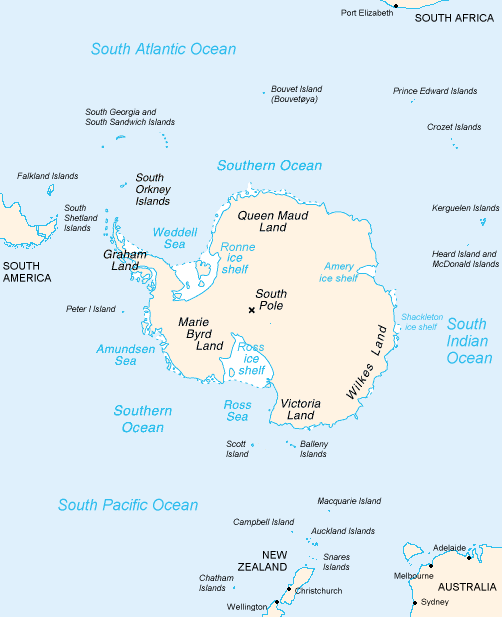
In February of 1819, William Smith - while sailing through Drake's Passage - is blown south and is the first to sight the South Shetland Islands. A year later, in January of 1820, the Royal Navy sent Smith and Edward Bransfield out to explore what lies south of the South Shetlands and they become the first explorers to see the Antarctic Peninsula. Later that month, Russian explorer Fabian Gottlieb von Bellingshausen - sailing down the west side of the peninsula - is the first to see part of the main continent. (Now, remember, this is nearly 330 years after Columbus first discovered the West Indies.)
In February of 1823, James Weddell sails to 74 S into the Weddell Sea. (Due to ice, no one is able to repeat that feat for eighty years!) Weddell never saw land, but in February of 1831, John Biscoe sights the main continent from the Indian Ocean side, just under Madagascar. John Balleny discovers the Bellany Islands by sailing south from New Zealand in 1839, and a year later Charles Wilkes leads a team that sees the portion of the continent that lies below western Australia, now known as Wilkes Land.
Expeditions throughout the 19th century continued to provide a more and more detailed mapping of Antarctica's coastline . In the 20th century, exploration onto the continent itself began.
Now, why in the world am I going on and on about the discovery and mapping of Antarctica? Because there is a story here that reads:
A map due to be unveiled in Beijing and London next week may lend weight to a theory a Chinese admiral discovered America before Christopher Columbus.The map, which shows North and South America, apparently states that it is a 1763 copy of another map made in 1418.
If true, it could imply Chinese mariners discovered and mapped America decades before Columbus' 1492 arrival.
...........................Chinese characters written beside the map say it was drawn by Mo Yi Tong and copied from a map made in the 16th year of the Emperor Yongle, or 1418.
Here is the map in question:
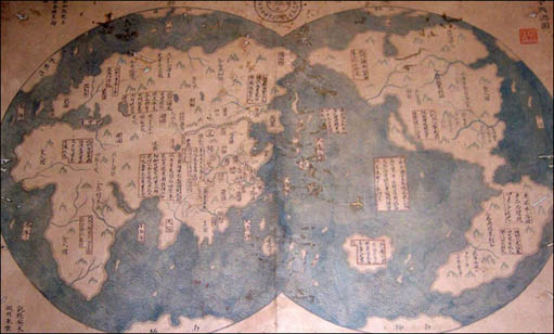
Notice that all of the contients are represented.
According to the Economist magazine, Mr Liu only became aware of the map's potential significance after he read a book by British author Gavin Menzies.The book, 1421: The Year China discovered the World, made the controversial claim that a Chinese admiral and eunuch, Zheng He, sailed around the world and discovered America on the way.
Zheng He, a Muslim mariner and explorer, is widely thought to have sailed around South East Asia and India, but the claim he visited America is hotly disputed.
While I think that it's highly doubtful that a Chinese vessel would have made it all the way across the Pacific Ocean and sailed up and down the coasts of the American continents to gather the info that could produce that map (and all in the year 1418... or 1421, whichever makes more sense...), I think it's downright rediculous to suggest that he would have mapped the coastline of Antarctica as well, including what appears to be a defined Ross Sea.
Even if it does prove to have been drawn in 1763, sceptics will point out that we still only have the mapmaker's word that he copied if from a 1418 map, rather than from a more recent one.
Even if the map was made as an original in 1763, it would predate the first European sighting of the Antarctic peninsula by 57 years, to say nothing of the discovery and mapping of the continent itself.
Nope. I predict that the forthcoming carbon dating of the map will show that it was drawn sometime in the latter half of the 19th century. Just a prediction. I could be wrong.
Posted by Tuning Spork at January 14, 2006 03:46 PM | TrackBackCool entry.
But the start: "First, the Earth cooled". That reminded me of the great scene in Airplane where the air traffic controller was asked how it all started and he said, something like, "first, we had dinosaurs and then they died and made oil and then the arabs came and bought Mercedes Benz's". Loved that one.
Posted by: RP at January 14, 2006 04:47 PMI loved Airplane!. I'll bet that was the inspiration for the opening line!
Well, I wouldn't be surprised, anyway.
Posted by: Tuning Spork at January 15, 2006 09:16 PM